Product overview
D-ESSM uses Spire’s downscaling methodology to enhance the spatial resolution of D-MSSM from 6 km to 500 m. Long-term Sentinel-1 SAR backscatter data establishes a robust connection between regional and local-scale soil moisture conditions. Where downscaling cannot be applied (densely vegetated areas, cities, water bodies), the pixel is infilled with D-MSSM gridded to 500 m.
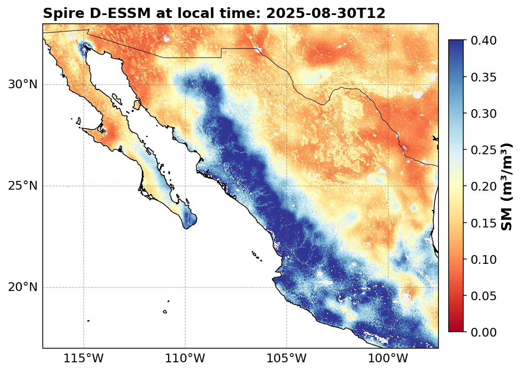
Figure 1:D-ESSM enhanced surface soil moisture over Mexico, 30 August 2025. Values in m³/m³.
| Property | Value |
|---|---|
| Spatial resolution | 500 m (0.0045° grid spacing) |
| Data level | L5 |
| Temporal coverage | May 2015–present |
| Coverage | Global |
| Unit | m³/m³ |
Variants:
d-essm— Standard product with ~4-day latencyd-essm-nrt— Near-real-time product with ~1-day latency
NetCDF4 format
Global attributes
| Attribute | Description |
|---|---|
description | Daily Enhanced Surface Soil Moisture |
creator | SPIRE GLOBAL |
processing_center | Spire EILAND |
file_created_time_utc | UTC creation timestamp |
data_level | L5 |
source | D-MSSM vMA.mi and Sentinel-1 downscaling parameters vMA.mi |
input_data_version | Input data release version (e.g. v02.01.98) |
release_tag | Data release version (e.g. v04.00.98) |
code_version | Production code version (may not be present in all files) |
git_hash | Production code commit hash (may not be present in all files) |
grid_mapping | spatial_ref |
feed | Data tier: "standard" or "nrt" |
Variables
| Variable | Description | Dims | Type | Fill value | Scale factor | Unit |
|---|---|---|---|---|---|---|
d_essm | Daily Enhanced Surface Soil Moisture downscaled from D-MSSM | (y, x) | uint8 | 255 | 0.005 | m³/m³ |
eflag | Enhanced flag — indicates where downscaling was applied | (y, x) | uint8 | 255 | — | — |
qflag | Quality flag — 8-bit flags recording surface conditions | (y, x) | uint8 | 255 | — | — |
aflag | Advisory flag — 0 = recommended, 1 = not recommended | (y, x) | uint8 | 255 | — | — |
y | Latitude coordinate | (y) | float64 | NaN | — | degrees_north |
x | Longitude coordinate | (x) | float64 | NaN | — | degrees_east |
spatial_ref | Coordinate reference system (WGS 84, EPSG:4326) | () | int64 | — | — | — |
Enhanced flag (eflag)
The eflag indicates whether the pixel value comes from the downscaled (enhanced) product or from the fallback D-MSSM gridded to 500 m:
0 — Enhanced (downscaling was applied, i.e. D-ESSM)
1 — Not enhanced (D-MSSM infill at 500 m)
Quality flag (qflag)
The D-ESSM quality flag uses 8 bits and has different condition definitions compared to D-MSSM, reflecting the higher-resolution ancillary datasets used.
| Bit | Condition | Interpretation |
|---|---|---|
| 0 | Terrain ruggedness | 0: not present; 1: complex topography present |
| 1 | Urban area | 0: no urban area; 1: urban area detected |
| 2 | Permanent water body | 0: no permanent water body; 1: permanent water body detected |
| 3 | Periodic water body | 0: no periodic water body; 1: periodic water body detected |
| 4 | Dense vegetation | 0: no dense vegetation; 1: dense vegetation detected |
| 5 | Patchy vegetation | 0: no patchy vegetation; 1: patchy vegetation detected |
| 6 | RMSE of downscaling | 0: no model mismatch; 1: spatiotemporal model mismatch between fine- and coarse-scale soil moisture |
| 7 | Freeze/thaw | 0: no frozen ground; 1: frozen ground detected |
Sources of conditions at 500 m resolution:
Terrain ruggedness: Terrain Ruggedness Index (TRI) derived from the 90 m Copernicus DEM (2021-1). Pixels with a median TRI exceeding a high threshold are flagged.
Urban areas / Dense vegetation: Derived from ESA WorldCover v200 (2021) at 10 m, downsampled to 500 m.
Permanent / Periodic water bodies: Derived from the JRC Global Surface Water product (VER5-0) seasonality layer.
Patchy vegetation: Derived from ESA WorldCover v200.
RMSE of downscaling: Indicates model mismatch between fine- and coarse-scale soil moisture.
Freeze/thaw: Carried over from D-MSSM input, upsampled from 6 km to 500 m.
GeoTIFF format
D-ESSM GeoTIFF files contain encoded soil moisture values with a no-data value of 255. Each delivery includes a corresponding advisory flag GeoTIFF layer.
| Tag | Description |
|---|---|
creator | SPIRE GLOBAL |
code_version | Production code version |
data_level | L5 |
description | Daily Enhanced Surface Soil Moisture |
file_created_time_utc | UTC creation timestamp |
git_hash | Production code commit hash |
input_data_version | Input data release version |
processing_center | Spire EILAND |
release_tag | Data release version |
short_name | D-ESSM (data) or AFLAG (flag) |
source | D-MSSM vMA.mi and Sentinel-1 downscaling parameters vMA.mi |
units | m³/m³ |
CRS | Coordinate Reference System |
CSV and GeoJSON format
| Variable | Description | Type | Fill value | Unit |
|---|---|---|---|---|
ref_local_time | Reference local time for each observation | datetime64[ns] | — | — |
d_essm | Daily Enhanced Surface Soil Moisture | float32 | NaN | m³/m³ |
eflag | Enhanced flag | float32 | NaN | — |
qflag | Quality flag | float32 | NaN | — |
aflag | Advisory flag | float32 | NaN | — |
lat | Latitude | float64 | NaN | degrees |
lon | Longitude | float64 | NaN | degrees |
geometry | Point geometry (WKT format) | string | — | — |
JSON (point API) response
{
  "data": [
    {
      "location": {
        "coordinates": {
          "lat": 48.80,
          "lon": 2.30
        }
      },
      "times": {
        "valid_time": "2026-02-10 12:00:00"
      },
      "values": {
        "d_essm": 0.245,
        "eflag": 0.0,
        "qflag": 0.0,
        "lat": 48.80,
        "lon": 2.30,
        "aflag": 0,
        "feed": "standard"
      }
    }
  ],
  "meta": {
    "message": null
  }
}